3dfier - Free Open-Source Tool for Transforming 2D Data into 3D Models

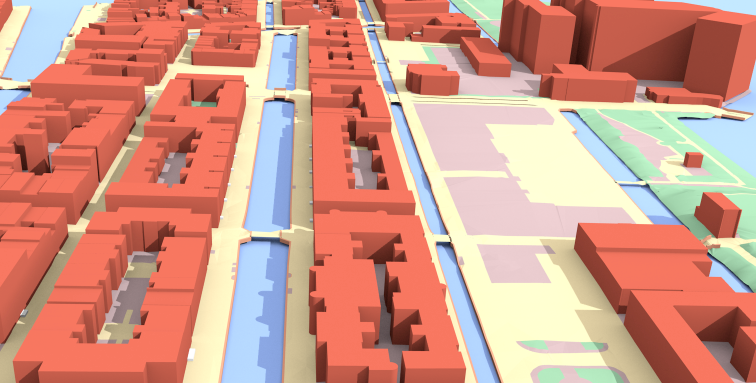
Table of Content
3dfier is an open-source tool developed by TU Delft that specializes in converting 2D geographical data into 3D models. Designed for use in urban planning, GIS, and other spatial analysis applications, 3dfier automates the process of transforming flat data into detailed 3D representations.
How does it work?
The elevation is obtained from a point cloud (we support LAS/LAZ at this moment), and the semantics of every polygon is used to perform the lifting. That is, water polygons are extruded to horizontal polygons, buildings to LOD1 blocks, roads as smooth surfaces, etc.
Every polygon is triangulated (constrained Delaunay triangulation) and the lifted polygons are "stitched" together so that one digital surface model (DSM) is constructed.
Our aim is to obtain one DSM that is error-free, i.e. no intersecting triangles, no holes (the surface is watertight), where buildings are integrated in the surface, etc. This surface will then be used as input in simulation software for instance.
The lifting options can be configured in the YAML file provided, an example is provided in /resources/config_files/myconfig.yml. Any 2D input (which should be a planar partition) can be used as input, and each class must be mapped to one of the following:
- Building
- Terrain
- Road
- Water
- Forest
- Bridge
- Separation (used for walls and fences)
It is possible to define new classes, although that would require a bit of programming.
Output is in the following formats: OBJ, CityGML, CityJSON, CSV (for buildings only, i.e. their ID and height (ground+roof) are output in a tabular format), PostGIS, and STL. The ID of each polygon is preserved, and there is a 1-to-1 mapping between the input and the output.
Key Features
- Automated 2D to 3D Conversion: 3dfier automates the conversion of 2D GIS data into 3D models, saving time and reducing manual effort.
- Customization Options: Users can customize the conversion process with various parameters to fit specific project requirements.
- Integration with GIS Tools: The tool integrates smoothly with common GIS software, allowing for seamless workflows between data preparation and 3D modeling.
- Support for Multiple Data Types: 3dfier supports various input data types, including shapefiles, 3D city models, and elevation data.
- High-Quality Output: The generated 3D models are accurate and detailed, suitable for use in simulations, urban planning, and visualization.
- Open-Source Flexibility: As an open-source project, 3dfier allows for modifications and enhancements, encouraging contributions from the community.
3dfier is an essential tool for anyone working with geographic information systems or urban planning who needs to bring their 2D data into the third dimension. It simplifies the conversion process, making it easier to create accurate 3D models from flat data.
License
GPL-3.0
Resources
For more information and to start using 3dfier, visit the GitHub repository.
 tudelft3d