16 Open-source Library and Frameworks to Build 3D Maps and 3D Globe!
From CityGML to SLAM: 16 Essential Open-Source Geospatial Apps for Developers

As a developer working with vector data, geospatial visualization, and real-time 3D mapping, I’ve spent countless hours exploring libraries that can turn raw datasets into interactive, beautiful, and intelligent experiences. Whether it’s for urban planning, civil engineering, robotics, or digital twins, the right tool makes all the difference.
In this post, I’m diving deep into the most powerful open-source 3D and geospatial tools shaping the future of spatial computing. I’ve personally used several JavaScript libraries like MapLibre GL JS, deck.gl, CesiumJS, and Tangram ES, each offering unique strengths in rendering vector tiles, handling large-scale datasets, and enabling real-time interaction.
From GPU-accelerated WebGL frameworks to AI-powered geological modeling, these tools are not just for cartographers. They’re essential for civil engineers building smart infrastructure, architects designing cities, robotics teams developing autonomous navigation systems, and developers creating immersive web apps.
Why This Matters
Vector data is the backbone of modern maps, lightweight, scalable, and perfect for dynamic updates. Libraries like MapLibre GL JS and deck.gl use GPU-powered rendering to visualize millions of points, heatmaps, and 3D buildings in real time. With 64-bit precision (deck.gl) and multi-resolution support (OctoMap), accuracy meets performance.
Who’s Using Them?
- City planners use Kepler.gl and azul to analyze urban density and model city growth.
- Civil engineers rely on GemPy for 3D geological models and osgEarth for terrain simulation.
- Autonomous vehicle teams use OctoMap and Tangram ES for real-time SLAM and embedded mapping.
- Web developers build interactive dashboards with CesiumJS, mapray.js, and TerriaJS.
- Researchers explore climate patterns using Martin to generate high-speed vector tiles from PostGIS.
Here is our top free and open-source 3D Map picks!
1- CesiumJS (Globe)
CesiumJS is a powerful, open-source JavaScript library that enables stunning 3D globes and 2D maps in any modern web browser, no plugins required. Built with WebGL, it delivers hardware-accelerated performance for smooth, real-time visualization of massive geospatial datasets.
It is ideal for applications in GIS, urban planning, climate modeling, aviation, defense, and IoT, CesiumJS supports dynamic data streaming, time-dynamic scenes, and rich 3D terrain & imagery.
It’s cross-platform, cross-browser, and designed for scalability, leveraging open standards like GeoJSON, KML, CZML, and glTF for seamless interoperability.

2- deck.gl
deck.gl is a high-performance, GPU-powered framework for visualizing large-scale datasets with precision and speed. Built on WebGL2/WebGPU, it enables real-time rendering of complex, interactive visualizations using a layered architecture, compose reusable layers like heatmaps, scatterplots, and 3D tiles for flexible, scalable analysis.
With 64-bit floating-point accuracy in the GPU, deck.gl ensures unmatched precision for geospatial and scientific data. Fully compatible with React, it integrates seamlessly with base maps from Mapbox, Google Maps, ArcGIS, MapLibre, and more, enabling rich, layered 2D/3D visual experiences.
Ideal for data scientists, developers, and analysts building dashboards, spatial analytics, and exploratory tools, deck.gl turns massive datasets into intuitive, interactive insights.
3- Kepler.gl
Unlock the full potential of your location data with Kepler.gl, a powerful, open-source geospatial analysis platform built on Deck.gl. Designed for large-scale datasets, it delivers lightning-fast rendering using WebGL, enabling real-time visualization of millions of points, heatmaps, hexagons, lines, GeoJSON, buildings, and more.
Perfect for data scientists, urban planners, and GIS analysts, Kepler.gl offers intuitive drag-and-drop file loading, time-playback filtering, geo-aggregation, and origin-destination correlation analysis, all with zero code. Visualize trends, detect patterns, and turn raw location data into actionable business insights.
For developers, it’s a fully embeddable, React-based toolbox that integrates seamlessly into custom apps. With support for DuckDB, GeoJSON, and real-time filtering, Kepler.gl is ideal for building interactive, data-driven maps.

4- maprayJS
mapray.js is a high-performance, WebGL-powered JavaScript library for creating stunning interactive 3D globes and digital twins in the browser. Built for realism and scalability, it delivers lifelike terrain, global data visualization, and immersive spatial experiences.

5- MapLibre
The MapLibre Organization is a leading open-source ecosystem for modern mapping. MapLibre GL JS delivers high-performance, GPU-accelerated vector maps in web browsers using TypeScript. MapLibre Native enables embedded map rendering in mobile, desktop, and IoT apps via C++ with OpenGL, Metal, or Vulkan.
The MapLibre Style Specification defines map appearance via JSON, enabling rich visualizations. Tools like Martin generate high-speed vector tiles from PostGIS or MBTiles. All components are open-source, modular, and ideal for developers building scalable, privacy-respecting geospatial apps.

6- OpenGlobus
OpenGlobus is a free, open-source TypeScript/ JavaScript library for interactive 3D maps at any scale, from planet to bee.
The library is powered by WebGL, it supports high-res terrain, imagery layers, thousands of 3D objects, and geometry measurement tools. Fast, visually stunning, and easy to integrate, OpenGlobus makes advanced geospatial visualization accessible for web projects.

7- Tangram: WebGL Maps for Vector Data
Tangram is a powerful, open-source JavaScript library for rendering interactive 2D and 3D maps in the browser using WebGL. Built as a Leaflet plugin, it supports OpenStreetMap, GeoJSON, TopoJSON, and binary vector tiles, from single files to tilesets.
The library is optimized for performance and visual quality, Tangram enables rich geospatial visualization with smooth, real-time rendering. It’s available in modern (ES module) and legacy (IE11-compatible) builds via unpkg. Ideal for developers building dynamic, data-driven web maps.

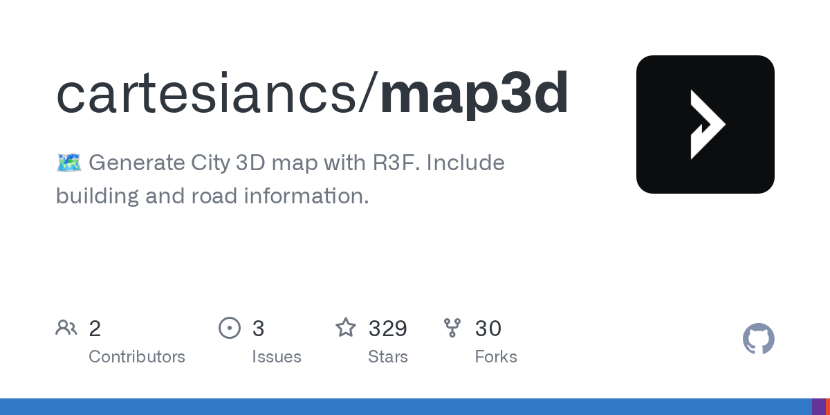
8- map3d
Meet map3d, your friendly tool to turn real-world locations into stunning 3D maps, right in the browser! Built with React-Three-Fiber, it’s super easy to create detailed 3D buildings, roads, and terrain. Want to share or use it in another app? Just export your map as a GLB file, free, fast, and fully open-source (MIT License).
It is perfect for digital twins, drone surveys, GPS markers, or just experimenting with spatial design. No fancy setup, no cost — just creativity unleashed.
9- Tangram ES
Tangram ES is a high-performance, open-source C++ library for rendering 2D and 3D maps from vector data using OpenGL ES, designed for real-time, interactive mapping on resource-constrained devices. It’s the lightweight, embedded counterpart to Tangram, optimized for mobile and edge platforms.
Supports multiple platforms: Android, iOS, macOS, Ubuntu Linux, Raspberry Pi, and Windows, with sample apps included for each. Ideal for developers building offline-capable, low-latency map experiences in apps, IoT devices, AR/VR, and embedded systems.
Built for speed, scalability, and portability — perfect for custom GIS tools, navigation apps, and spatial visualizations where performance and minimal footprint matter.

10- TerriaJS
TerriaJS is a powerful, open-source JavaScript library for building rich, web-based geospatial explorers, used in projects like Digital Earth Australia and NSW Spatial Digital Twin. It runs in the browser with no plugins, using Cesium for 3D globe or Leaflet for 2D fallback, and supports tens of thousands of layers across diverse formats.
Built entirely in the browser, it can be deployed as a static website — simple, fast, and low-cost to host. Supports GeoJSON, KML, CSV (region-mapped), GPX, CZML, zipped shapefiles, and over 20 web services including WMS, WFS, Esri, Mapbox, Cesium Ion, SDMX, 3D Tiles, GTFS, and more.
Its features include:
- Nested layer catalog: Mix and match layers independently for dynamic map mashups
- Native file support: Load GeoJSON, KML, CSV (region-mapped), GPX, GeoRSS, CZML, zipped shapefiles via drag-and-drop (no upload)
- Web service integration: Access WMS, WFS, WMTS, Esri Map/Feature Server, Bing Maps, Mapbox, Cesium Ion, OpenStreetMap, 3D Tiles, GTFS, SDMX, Sensor Observation Service
- Metadata search: Query CKAN, Socrata, OpenDataSoft, CSW, and SDMX services for datasets
- Dual mode: Switch between 3D globe (Cesium) and 2D map (Leaflet) with full 3D object support (CZML)
- Time-enabled layers: Auto-animate or manually scrub time for CSV, CZML, and WMS data
- Shareable URLs: Generate reusable links to save and share custom map views
- Global region support: Pre-mapped Australian ASGS regions (LGA, SA2, electoral districts), PHNs, SLAs, ISO country codes, and more
- Multilingual UI: Fully internationalized with translations in French, Italian, Japanese; community contributions in other languages
- Developer-friendly: Modular, open-source, built for web apps, dashboards, and public data portals
12- GemPy
GemPy is a free, open-source Python library for creating 3D structural geological models using an implicit modeling approach. It supports complex features like folds, faults, and unconformities, enabling rapid, GPU-accelerated geomodeling.
With probabilistic AI and Bayesian inference integration, GemPy excels in uncertainty quantification and model optimization. Built for geoscientists and researchers, it offers flexible 2D and 3D visualization via PyVista, Jupyter Notebooks, or export to Blender and LiquidEarth. Fully transparent and interoperable with tools like GemGIS, pyGIMLi, and SimPEG, GemPy empowers data-driven geological analysis.
The latest v3 release includes enhanced workflows, tutorials, and step-by-step guides for beginners and experts alike.
13- osgEarth

osgEarth is an open-source C++ library that brings geospatially accurate 3D mapping to desktop and embedded applications. Built on OpenSceneGraph and GDAL, it delivers high-performance terrain and map rendering with support for countless data formats, projections, and coordinate systems.
The library is an ideal choice for developers building GIS tools, simulations, digital twins, or visualization apps requiring real-world precision.
It is fast, scalable, and deeply integrated into the open-source geospatial ecosystem.
14- OctoMap

OctoMap is a high-performance, open-source C++ library for 3D occupancy grid mapping in robotics and autonomous systems. Built on an octree data structure, it enables robots to create full 3D environmental models that distinguish between occupied, free, and unknown spaces, essential for safe navigation and exploration.
Designed for real-time updates, OctoMap supports probabilistic sensor fusion, making it resilient to noise and dynamic changes. It dynamically expands as new areas are discovered, enabling scalable, multi-resolution mapping ideal for both high-level path planning and local obstacle avoidance.
The library is memory-efficient and compact, with support for compressed file storage, perfect for transferring maps between robots or storing large-scale environments.
Widely used in SLAM (Simultaneous Localization and Mapping), autonomous drones, self-driving cars, and robotic exploration, OctoMap delivers accuracy, flexibility, and performance.
15- Ascend Maps

Ascend Maps is a cross-platform, open-source mapping app for Android, iOS, Windows, and Linux, built on Tangram NG (a modern fork of Tangram ES) for high-performance vector and raster map rendering. It supports 3D terrain, offline maps, track recording & editing, saved locations, and customizable styles, including a clean, lightweight design for OpenStreetMap vector tiles.
With features like offline search, routing, plugin support for map sources, and tile caching, Ascend Maps is ideal for travelers, hikers, developers, and anyone who needs reliable, privacy-focused navigation without relying on cloud services. Available on the App Store, TestFlight, and desktop platforms, all free and open-source.
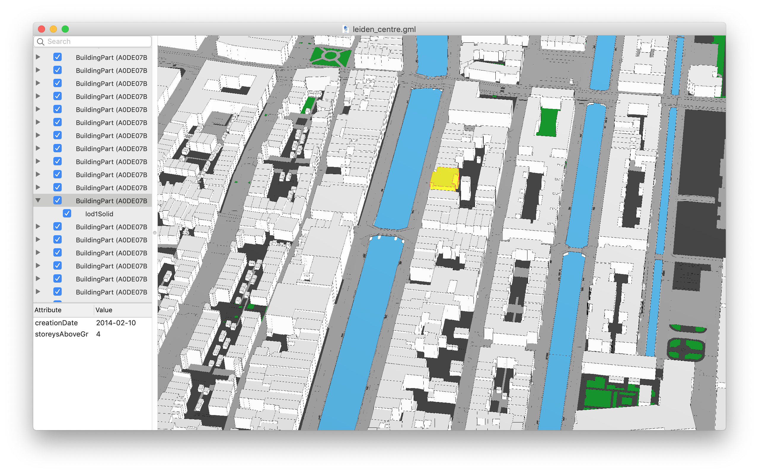
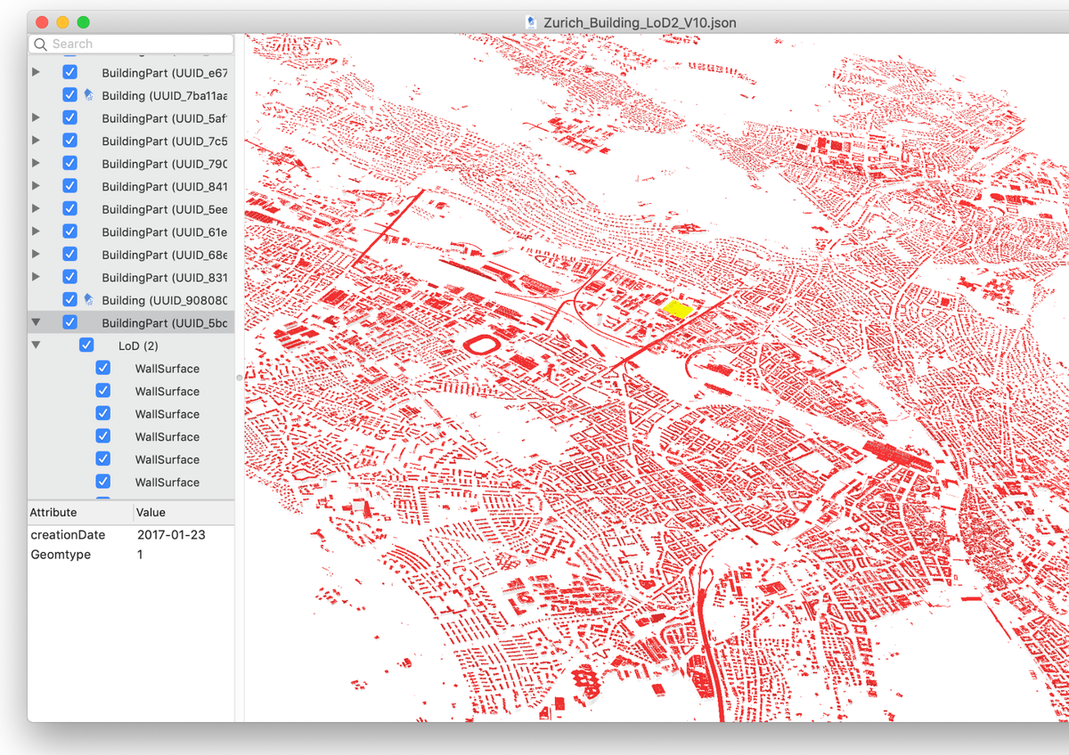
16- Azul
Azul is a free, open-source 3D city model viewer built for researchers, urban planners, and GIS professionals. It supports a wide range of geospatial formats including CityGML 1.0 & 2.0, CityJSON 1.0–2.0 (including text sequences), IndoorGML, OBJ, OFF, and POLY. Load multiple datasets, select objects by clicking or via the sidebar, toggle visibility, and explore detailed attributes, all with smooth, real-time performance.
It is designed for macOS 13+ with full support for Apple Silicon and Intel chips, azul offers an intuitive, stable experience for visualizing complex urban environments. Released under the GPLv3 license, it’s ideal for academic research, digital twin projects, and spatial analysis, no cloud, no fees, just powerful, local 3D visualization.