Design Beautiful Maps Easily with TileMill
TileMill is a modern map design studio powered by Node.js and Mapnik.


TileMill is a design environment developed by MapBox for cartography, constituting Mapnik as a renderer, CartoCSS as a stylesheet language, and a locally-served web interface with Node.JS as a server and based on Backbone.js for the client.
Older versions up to 0.10.x are available with a native GUI on all supported platforms.
TileMill works well to load OSM data from a PostGIS database, in addition to loading shapefiles, GeoTIFFs, GeoJSON files, CSV files, both locally and from URLs.
TileMill supports exporting to multiple formats: MBTiles, PDF, PNG, JPG and Mapnik XML configuration files. Mercator is the main-supported projection.
Features
- Create unlimited projects
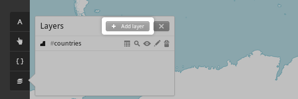
- Advanced layer manager
- Easily add map layers
- Import and export data
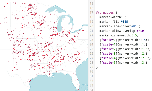
- Style your map with a plain CSS
- Add tooltips easily to your maps
- Add map markers
- Export maps to PDF, PNG, JPG, and map XML.
- Import data from comma-separated values (CSV) file
- Supports many Geo formats
- Import CSV from a URL
- Add a map legends with ease
- Add a map teaser
- Supports HTML for map legends
- Add MapBox Geodata
- Advanced zooming and marker grouping
- Supports CartoCSS
- Built-in support for high resolution tile
- Suitable for designing heat maps
- Export to MBTiles
- TileMill is tested on Linux with Node 8.11.3 LTS, and on MacOS 10.14 with Node 8.15.0 lts/carbon
- TileMill currently only works in server mode, there is no standalone GUI. Your browser is used for the interface.
- There are no native packages provided. Installation requires cloning this repo. See details below under Installation.
- Tilemill should theoretically work on the Windows platform, but it isn't tested
TechStack
The project is built using Node.JS, and Backbone.js.
License
TileMill is released under the BSD 3-Clause "New" or "Revised" License.